The Leeds Data Mill: A New Hope (Guest post)
Written by: Tom Forth, IMACTIVATE, 25/03/2014
When Star Wars was released in 1977 few people know it was a sequel. In 1999 when the Phantom Menace came out, most people wished they’d never found out. The analogy is strained, but I think it’s important. Leeds Data Mill is nothing new, it’s just the latest installment in a data story that our region’s governments, companies, and charities have been telling in private for decades.
The difference now is that the challenges are so daunting, and the potential so huge, that organisations in our region are ready to drop their guard and work together. That means not just sharing their data with each other, but also sharing their data with anyone who cares to look. It means opening themselves up to possible criticism now, in return for the possibility of insights and innovations that improve services and save money in the future.
The Leeds Data Mill hackathon at Leeds City Museum on the 8th and 9th of March was the first chance for about 50 interested people to have a look at that data. We’ve documented what we did at http://notasgreenascabbagelooking.wordpress.com/2014/03/08/hack-the-government-at-leeds-city-museum/ so I’ll just share the best bit here.
Leeds planners are doing a good job
When flooding hits the UK, we find someone to blame. After we’ve blamed the environment agency we look for new targets and for a lot of people that means the greedy developers and corrupt councils who have brought flooding on themselves by building on the floodplain.
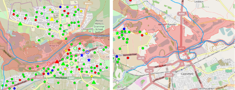
Now I agree that if you build a house on a floodplain you shouldn’t be surprised if it floods. And I agree that our current planning permissions system is a mess. But I’ve never been convinced that this type of building happens that often in the UK nowadays. So we used opendata to see ask much of a problem building on the floodplain is in Leeds.

Putting the historical floodplains around Leeds (from the environment agency) on a map, and overlaying the last five years planning applications (from Leeds Council) gives us an early answer.
The results are striking and the data tells a clear story. The maps of Castleford and Otley show that the planners at Leeds city council are doing a great job of stopping building on floodplains.
No-one would believe the council if they said it themselves so I’m saying it for them.
If you disagree, I’d love you to prove me wrong; the data’s open after all!
The full dashboard is available at
http://city-dashboard.poggs.co.uk:8081
—
Blog Post by Thomas Forth / @tomforth
